OUR MOTIVATION
Our team's idea of developing a navigation and feature detection system for an unmanned aerial vehicle (UAV) was inspired by relief efforts in disasters like chemical leakage, fire and other natural disasters.
In the disaster relief efforts, the local environments are often in unfavourable conditions (extreme temperature, high radiation or toxic level) in which it is too dangerous for a personnels to actually enter the disaster-hit zones to carry out relief efforts. In cases like this, an autonomous UAV can be an excellent alternative for entering disaster zones and carry out disaster relief tasks in place of humans.
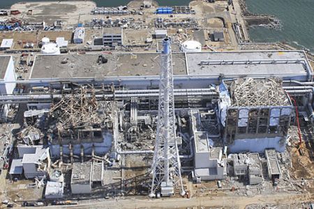
Figure 1. The above picture was taken from the Fukushima nuclear plant crisis last year, and the place is too dangerous for humans to enter due to high radioactive level. Our team is hoping to develop a navigation system for the UAVs which can be used in disaster relief efforts in situations like the above.
(Picture taken from http://ezli007.blogspot.com/2011_05_27_archive.html)
NEEDs STATEMENT
Keeping the above motivation in mind, there is a need for a versatile UAV that is capable of autonomous navigation in closed spaces and direct (active) interaction its environment.
Based on this need, the team is developing a navigation system for an UAV which enables an UAV to recognize specific geographic features and plan a flight path of its own.
OUR GOALS & OBJECTIVES
To show that our team's developed UAV navigation system is fully functional and working, we have come up with the simple demonstration method which is both presentable and practical.
With the implementation of our developed navigation system, a UAV should be able to locate and navigate through a window with a coloured frame that is approximately 0.8 m by 0.8 m in size. This test will be used to demonstrate the feature recognition (recognition of window frame) and obstacle avoidance functionality.
The actual performance of the window is to be evaluated based on the following constraints and criteria
- Weight: The UAV is expected to lift upto 150 grams of weight, and the overall mass of the sensor package needs to be between 120 to 150 grams
- Detection Range: The UAV must be able to detect the window from at least 4 meters away
- Obstacle Avoidance: The UAV must be able to navigate through the window without any collisions.
- Time: The total time taken to navigate through the window should be minized and kept under a minute
- Cost: The cost of navigation system for UAV should be minimized
We are expecting that the feature recognition and obstacle avoidance functionality of the navigation system can be widely used in practical applications such as:
- Entrance or exit to/from a room or builidng through a small opening or window
- Docking an UAV into its proper place upon its return